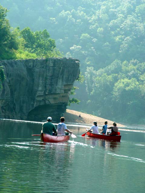
Did you ever wonder what America’s rivers looked like when the very first wanderers heard the roar of water over rocks in the distance? Ever think it would be nice if somewhere clear water still flowed free, far from industry, pollution and dams…a river set aside for canoes, campfires and cameras?
Some rivers soothe and some rivers challenge. The Buffalo River can do both, but with its towering limestone bluffs and gentle sweeping turns, mostly it inspires. This clear, free-flowing stream inspires backpackers as well as water enthusiasts, but more importantly it inspired Congress to name the Buffalo River as America’s first national river in 1972, hopefully preserving forever the crystal waters of this great recreational river.
From its beginning as a spring in the Ozark National Forest near the highest point in western Arkansas, the Buffalo tumbles out of the Boston Mountains on the scenic stream’s 150-mile journey to join up with the White River. Outdoor enthusiasts have almost 95,000 acres of public land to enjoy along the way. This is a big backcountry with many types of recreational opportunities and the river has three distinct sections.
Serious backpackers and hikers know the upper Buffalo well, with its many caves and springs. In the early spring when water levels are high, this is where seasoned paddlers knock off the winter’s rust. Water levels are all-important and for quick reference, go to www.nps.gov/buff/. This National Park Service Web site offers real-time water levels, recommended floating levels, rainfall reports, watershed maps and message of the day. This section of the Buffalo can challenge the experienced and overpower the beginner in high-water conditions. Veteran canoers like to put in around Ponca in the early spring and then move on down to Hasty and Carver as the water level goes down. The upper Buffalo also has two camping areas designed for horses, Steel Creek and Erbie. Outfitters like Wild Bill also offer trail rides along the middle section of the Buffalo.
In the early 1980s the Fish and Game Commission, along with the National Park Service, relocated 112 elk from Colorado and Nebraska to this area. Now approximately 500 elk live along the upper Buffalo, making this the only self-sustaining elk herd in the southeastern U.S. Occasionally in May, a spindly-legged newborn can be seen following his mother along the Buffalo and in late September and early October, the shrill bugle of bull elk echoes off Limestone bluffs and fades into the many sounds along a wild and free river.
The middle section is always a great float, unless the water level is too high and the river is closed. Most of the true rapids are behind you now and this part of the Buffalo is better known for good smallmouth bass fishing, swimming holes and impressive rock formations like Skull Rock, the Nars and Devil’s Tea Table.
The Tyler Bend Visitors Center has historical displays and artifacts from the area, plus a large campground and hiking trails.
The lower section of the Buffalo starts near the old mining boomtown aptly named Rush. Successful zinc mines just before the turn of the century had almost 5,000 workers living in Rush valley. An old forge and a handful of historic buildings are all that remain along the river now. Just below Rush is an S-turn in the Buffalo known as Clabber Creek shoals. In high-water conditions, this spot can be interesting, but for the most part the lower Buffalo is famous for some of the highest bluffs and deepest holes anywhere on the river. From Rush on down to the Buffalo’s confluence with the White River, floaters will find 27 miles of deep holes, towering cliffs and pristine sandbars just right for camping.
John Muir saw the Buffalo River. Henry Thoreau was here, as was Thomas Moran. And the best part is…it’s still the same incredible river.

Buffalo River

River patrol

Most places on the river you can just lay back and float along.

"You can see a dime in 10 feet of water," said Williard Stoops, Guide with Wild Bill's Outfitter

The canyons are overpowering when you are in a canoe.

Snorkelers were diving up and down the river.

The river changed its appearance around every corner.

Families floating down the Buffalo had plenty of river to spread out and enjoy it alone.

Families can canoe down the Buffalo and camp for days.

Catching smallmouth bass on the Buffalo.

Williard Stoops, Guide with Wild Bill's Outfitters has lived most of his life along the Buffalo and was full of information about the area. He can be reached at (870) 449-6105 for guided trips.

When you get ready to explore, you just pull your canoe over.

You can barely see two canoes next to the canyon walls in the distance.

This couple has taken countless floating trips down the Buffalo.

Winding through the canyons.

Kids camping with their parents on the Buffalo would hike upstream and ride the current back to the camp.

Everyone at Wild Bill's Outfitter accomodated our every wish. We have provided a link to Wild Bill's at the end of the story for additional information.

Elva's Cedar Cabin is more than just a cabin, it is a home away from home. Our stay was made perfect by the owner, Elva Pera Kelly. To get more information on the cabin, we have provided a link at the end of the story.

In the flood of 1982, the Buffalo River ran over this bridge. A photo on the bulletin board at Wild Bill's captured the moment.
For more information on the Buffalo River, visit www.nps.gov/buff/ or http://www.buffalonationalriver.com/
For information about cabins, canoe trips, kayaks, john boats, trail rides as well as fishing and hunting guides, visit Wild Bill's Outfitters at www.ozark-float.com
To learn more about a secluded cedar cottage designed with an artist's touch, visit http://www.ozarkcabins.com/cedarcottage/


