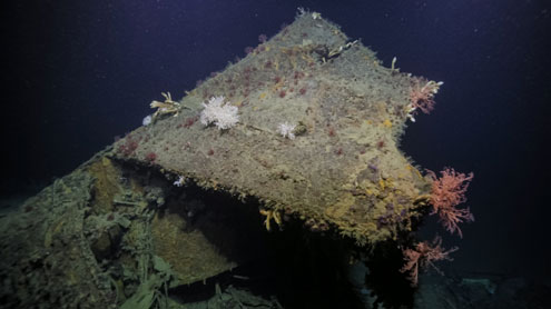
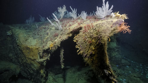
Honiara, Solomon Islands (July 8, 2025) A team of scientists and explorers aboard the Exploration Vessel (E/V) Nautilus has located and imaged the bow blown off the World War II heavy cruiser USS New Orleans for the first time. Using an ROV to investigate a target found during seafloor mapping operations by University of New Hampshires uncrewed surface vessel (USV) DriX, the team found the bow resting at ~675 meters deep in the Solomon Islands Iron Bottom Sound and reilluminated this improbable story.
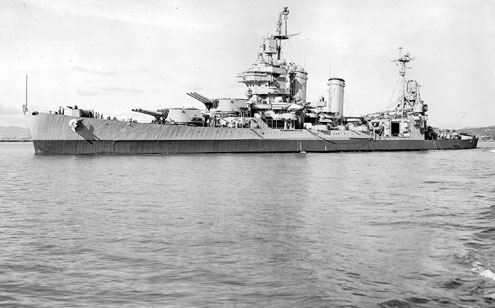
During the November 1942 Battle of Tassafaronga offshore of Guadalcanal, USS New Orleans was hit by a Japanese Long Lance torpedo, catastrophically detonating the forward magazines and tearing off nearly one-third of the ship, including the bow. The explosion killed over 180 crew. Bow-less and flooding, New Orleans was heroically saved by crew members, who stayed at their posts and saved their ship but not themselves, receiving three posthumous Navy Crosses. The ship limped back to the nearby harbor, where, using coconut logs, the crew was able to stabilize New Orleans well enough to sail backward to the United States for permanent repairs.
By all rights, this ship should have sunk, but due to the heroic damage control efforts of her crew, USS New Orleans became the most grievously damaged U.S. cruiser in WWII to actually survive. To find the bow of this ship is an opportunity to remember the sacrifice of this valiant crew, even on one of the worst nights in U.S. Navy history, said Naval History and Heritage Command Director Samuel J. Cox, U.S. Navy Rear Admiral (retired).
The wreckage was discovered by an expedition team aboard E/V Nautilus, working to combine ocean technologies to demonstrate new efficiencies in ocean exploration. The expedition led by Ocean Exploration Trust (OET) and supported by NOAA Ocean Exploration via the Ocean Exploration Cooperative Institute utilizes the mapping capabilities of USV DriX and the seafloor exploration and imaging capabilities of OETs remotely operated vehicles (ROVs) deployed together.
The discovery highlights the power of having multiple scientists and technologies work together to achieve a common goal, said Ocean Exploration Trusts Chief Scientist Daniel Wagner. The wreck was located during seafloor mapping operations by an uncrewed surface vehicle, then investigated shortly thereafter by a deep-diving remotely operated vehicle. This imagery was viewed in real-time by hundreds of experts around the world, who all worked together to make a positive identification of the finding."
The team spent four hours imaging the site with onboard archaeologists and experts from all former combatant nations contributing via livestreaming telepresence. Together, this team spotted details in the ships structure, painting, and anchor to positively identify the wreckage as New Orleans.
"Finding the New Orleans' bow highlights the range of vivid maritime heritage stories we are discovering on the seafloor as well as the team's impressive capabilities to identify small targets in deep water and rapidly bring us all with them to see these historic sites using remotely operated vehicles," said Captain William Mowitt of the NOAA Corps, acting director of NOAA Ocean Exploration. "None of this would be possible without the expertise of NOAA, OET, and the many partners on Nautilus and ashore."
USS New Orleans' keel was laid in March 1931 at the Brooklyn Navy Yard; the text Navy Yard was visible, stamped on the base of the anchor during the exploration. New Orleans was part of some of the heaviest fighting during the Pacific War, beginning at Pearl Harbor and continuing with action at Coral Sea, Midway, Guadalcanal, Gilbert, Marshall, Marianas, Philippine, and Okinawa campaigns.
Over eighty years after the war, this expedition explores Iron Bottom Sound, the stage of five major naval battles between August and December 1942, which resulted in the loss of over 20,000 lives, 111 naval vessels, and 1,450 planes from the Allied forces and the Empire of Japan. To date, only 30 of the military ships lost in deep waters here have been located, with dozens remaining to be found. The expedition is streaming live on NautilusLive.org, a 24-hour platform that brings ocean exploration directly to viewers to connect the next generation of explorers with the excitement of discovery.
Led by OET President and famed explorer Dr. Robert Ballard, the Maritime Archaeology of Guadalcanal expedition, exploring historically significant shipwrecks in the Iron Bottom Sound, is supported by NOAA Ocean Exploration via the Ocean Exploration Cooperative Institute. This exploration is made possible by the expertise, support, and collaboration of many partners, including NOAA Ocean Exploration, U.S. Naval History and Heritage Command, Solomon Islands government, the University of New Hampshire Center for Coastal and Ocean Mapping/Joint Hydrographic Center, and Japanese, Australian, and New Zealand colleagues.
----------------------------------------------------------
About the Ocean Exploration Trust
The Ocean Exploration Trust was founded in 2007 by Dr. Robert Ballard to explore the ocean, seeking out multi-disciplinary discoveries while pushing the boundaries of STEAM education and technological innovation. Our international program is launched from aboard the Exploration Vessel (E/V) Nautilus, offering live exploration to participants on shore and the public via live video, audio, and data feeds. Learn more about Ocean Exploration Trust. The 2025 E/V Nautilus expeditions are primarily sponsored by NOAA Ocean Exploration via the Ocean Exploration Cooperative Institute. OET program sponsors and partners for 2025 also include the Office of Naval Research, QPS, and the Phillip Stephenson Foundation. Learn more about our partners and sponsors.